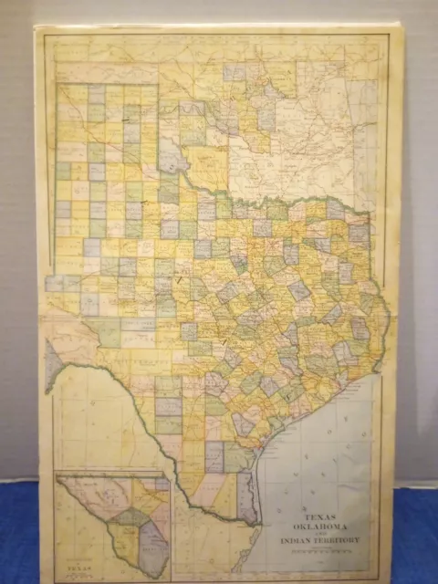
1886 Map Of Texas Oklahoma And Indian Territory
$172.13 Buy It Now or Best Offer, Click to see shipping cost, eBay Money Back Guarantee
Seller: pickersoutlet ✉️ (1,399) 100%,
Location: Maryland Heights, Missouri, US,
Ships to: US & many other countries,
Item: 295891338623
1886 Map Of Texas Oklahoma And Indian Territory .
Pickersoutlet is where Pickers come to Pick!!
Be sure to follow us online!!
View our other items online!
Map is two pieces that was connected with archive tape.
Seems to come from an old book discussing Texas. Colors are vivid
This is a beautiful hand-colored map of Texas, Oklahoma, and Indian Territory. It was printed in 1886 and is an original piece. The map is illustrated and features important geographical details of the North American region. It is a perfect addition to any collection of historical Americana. The map is in great shape, ready to be displayed or framed.
- Language: English
- Illustrator: Hand colored map
- Special Attributes: Illustrated
- Region: North America
- Topic: Historical
- Subject: Americana
- Year Printed: 1886
- Original/Facsimile: Original
PicClick Insights - 1886 Map Of Texas Oklahoma And Indian Territory PicClick Exclusive
- Popularity - 7 watchers, 0.0 new watchers per day, 240 days for sale on eBay. Super high amount watching. 0 sold, 1 available.
- Best Price -
- Seller - 1,399+ items sold. 0% negative feedback. Great seller with very good positive feedback and over 50 ratings.
People Also Loved PicClick Exclusive

"RESOURCES AND DEVELOPMENT OF WASHINGTON TERRITORY" by Watson C. Squire, 1886
$145.00 Buy It Now 10d 11h
HISTORY OF COTTON COUNTY • OKLAHOMA Genealogy Indian Territory Pioneer Rare
$74.50 Buy It Now 9d 2h
1905 Henry Gannett A Gazetteer of Indian Territory (Oklahoma) USGS Bulletin 248
$25.00 Buy It Now 25d 14h
1885 AGRICULTURE REPORT AMAZING INDIAN TERRITORY MAP & Many Illustrations Flora
$14.00 Buy It Now 25d 0h
Government Report 1897 Oklahoma Territory Free Homesteading Indian Tribes
$14.99 Buy It Now 14d 11h 2 watchers
 Texas & Oklahoma Indian Territory 1890 scarce folio Scribner-Black map
$309.84$247.87 Buy It Now
 1904 Antique Map Of Texas Oklahoma Indian Territory New Mexico / Verso Mexico$38.97 Buy It Now or Best Offer
 2 watchers
 1904 Antique Texas Indian Territory Oklahoma Railroad Map 1475
$34.43$30.98 Buy It Now
 1881 McNally Map Texas Indian Territory Oklahoma Austin Houston Presidio
$549.44$439.55 Buy It Now


