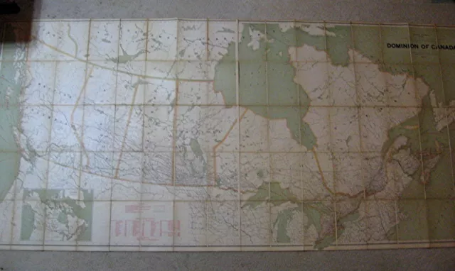
Antique map of Canada Huge Linen backed
Seller:  vytautus ✉️ (786) 100%,
Location: Butte, Montana, US,
Ships to: WORLDWIDE,
Item: 282321655326
Antique map of Canada Huge Linen backed. This is a very nice early Canadian printed map of the Western frontier of Canada. It was printed in Victoria B.C., in 1900, by The Land and Works Department. I have been unable to find another example of this map online. The map is aprox. 31 1/2" X 43". The map is in solid condition with slight areas of chipping and small tears some separation from the linen. It is in better condition than most maps this age I would say a solid 7 out of 10.
- Condition: The map is in good condition for age. Some separation from the linen backing edge chips wear and a couple of slight tears mainly on the edges. See pictures.
- Type: Map
- Original/Reproduction: Original
- Maker: Land and Works Department Victoria B.C.
- Rare map of canada: Linen backed map British Columbia
- Large map of Canada: Antique Canadian Map
- Early canadian Map: 1900 Map of Canada
- Yale District: Cariboo district
- Lillooet district: Kamloops division
- Western canada Map: North west teritory
- Early British Columbia map: Western canada Pioneer
- Burnaby village: Canadian homesteads
- osoyoos division: Yale BC
PicClick Insights - Antique map of Canada Huge Linen backed PicClick Exclusive
- Popularity - 1 watcher, 0.0 new watchers per day, 30 days for sale on eBay. Normal amount watching. 0 sold, 1 available.
- Best Price -
- Seller - 786+ items sold. 0% negative feedback. Top-Rated Plus! Top-Rated Seller, 30-day return policy, ships in 1 business day with tracking.
People Also Loved PicClick Exclusive
 3 watchers
 Canada Geological Survey wall map 1945 huge linen backed rare map Mines Geology
$1,032.79$826.23 Buy It Now 3 watchers
 Huge Folding Map DOMINION OF CANADA 1924 49" X 102" Dissected on Linen 4 Sec. 6A$1,032.79 Buy It Now


